Page updated 1 Dec 2022
Venus: global hypsometry
Venus’ global hypsometry (variations in surface elevation relative to a mean) is unimodal, unlike the Earth’s. The study of the cumulative hypsometric curve for both planets reveals that there exists a domain of elevation for which the relationship between the elevation and the square root of cumulative area percentage is linear. This domain covers about 80% of the mapped venusian surface and nearly all the terrestrial oceanic surface (55% of the earth’s surface) and corresponds to an elevation range of about 2000 m for both planets. It places an upper bound at 90 +/- 10 km for the modal thermal lithospheric thickness of Venus, similar to the Earth’s oceanic lithosphere. The low-excentricity, near-polar and relatively low altitude (220-400 km) orbit of EnVision offers the opportunity to obtain a high-resolved gravity field at each longitude and latitude of the Venusian globe. The analysis of the gravity field together with the topography gives insights on the lithospheric and crustal structure, allowing to better understand Venus’ geological evolution.
Venus: plains
About 70 % of Venus topography lies near the global mean average, consisting variously of smooth, gently undulating or ridged terrain. There is a huge variety of features found on these plains – from volcanic features (see-sides domes etc), tectonic features (e.g. wrinkle ridges etc), evidence of flows (canali), aeolian features (dune fields, parabolae). Are canali or other specific magmatic features confined to a past regime or still active today? Is there a correlation between mesospheric SO2 concentration and volcanic activity? Are crater floors effusively infilled and buried from below? Were the plains formed from a few massive outpourings in a short period of time or from many thousands of small flows over their entire history? Or were they formed, or modified, in an entirely different way?
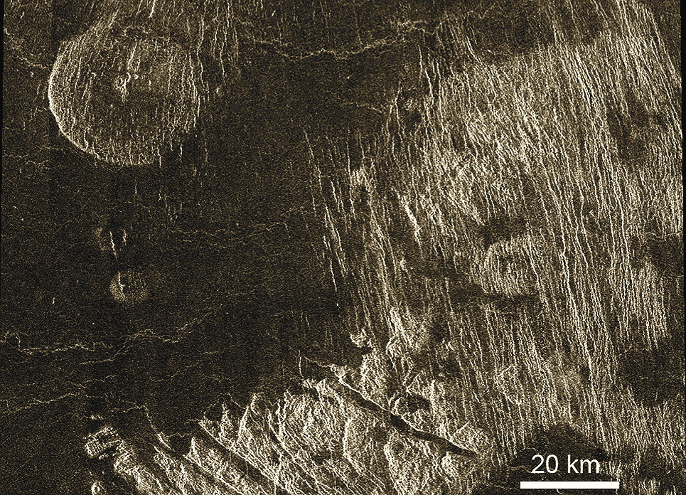
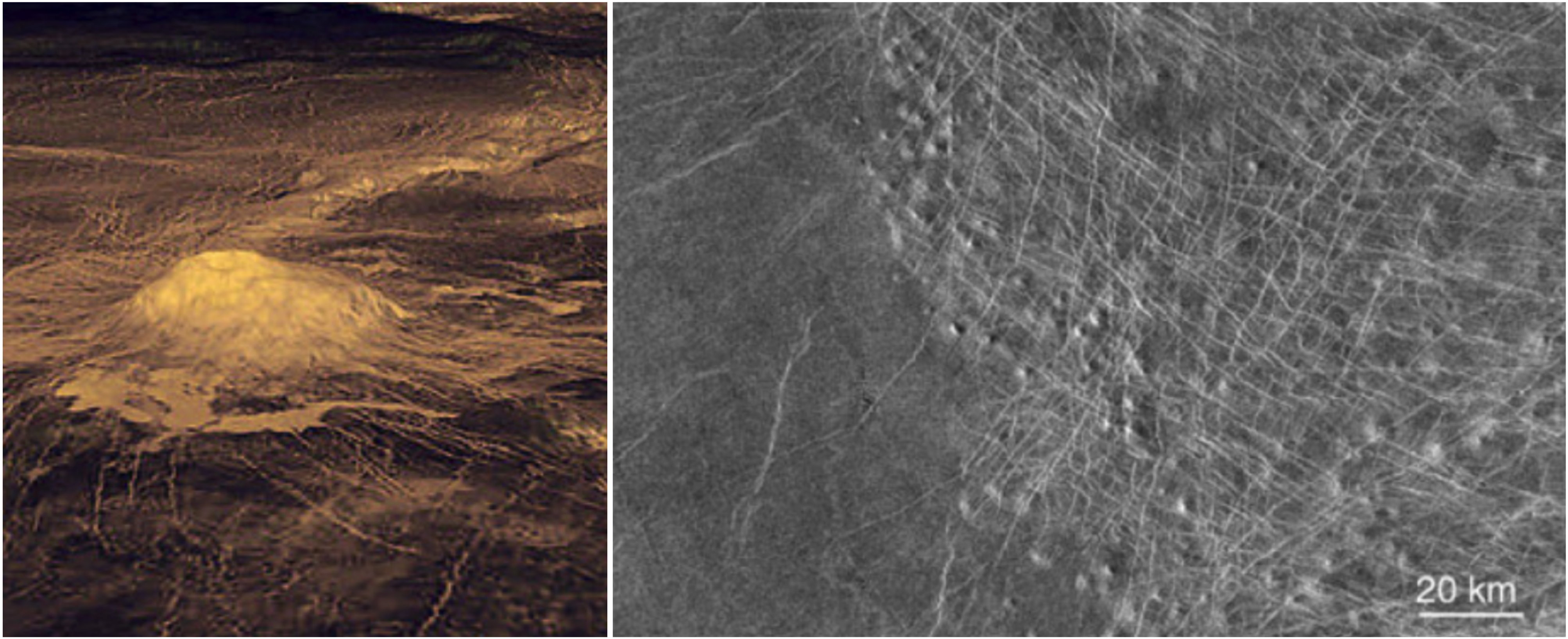
Venus: tectonic features
The surface of Venus is not organised into large plates like Earth’s oceans but it is partitioned into areas of low strain bounded by narrow margins of high strain, analogous to continental basins and microplates. Are these regions actively created and destroyed, like Earth’s oceans, or simply mobilised locally? What is the significance of the global network of elevated rift systems, similar in extent to mid-ocean ridges but very different in appearance? Unique to Venus are coronae, quasi-circular tectonic features, typically 100–500 km across, with a range of associated volcanic features. Are coronae the surface expression of plumes or magmatic intrusions? What role do they play in global tectonic and volcanic change?

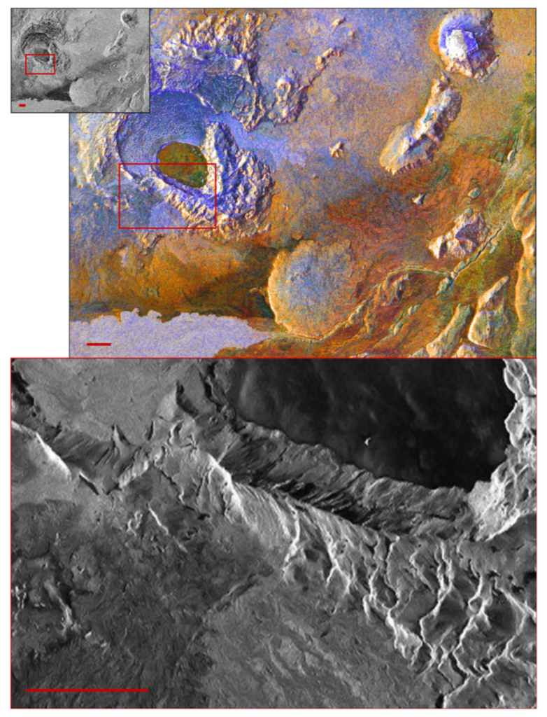
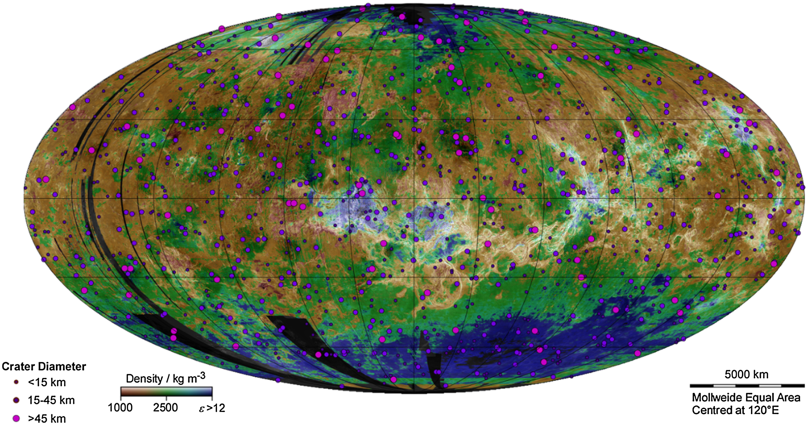
Venus: impact craters
Impact craters give absolute age of some surfaces, but too few can be seen to allow dating constraints on different geological units. On Venus, the spatial distribution of impact craters cannot be distinguished from a completely spatially random population. This indicates a relatively young surface (less than 600-800Ma). There are open questions about buried features and the nature of volcanic resurfacing. It could have occurred steadily or experienced catastrophic episodes. A debate still exists between “directional” and “non-directional” models. Mapping impact craters and their geological alteration processes will allow to construct a global chronology of the surface that is currently missing.
Venus: tesserae highlands
Representing about 10 % of the Venus surface, tesserae may represent the oldest terrain on Venus. The processes which have shaped them are unknown. They have never been visited by any lander, so their composition is unknown. They might be either felsic (formed in a water-rich environment) or mafic rock types. Detailed morphology and their tectonic features, coupled with characterisation of surface emissivity and subsurface features, will provide an extensive investigation of these regions.
Venus: volcanic rises
Given its similar size and bulk composition as Earth, Venus is expected to be volcanically and tectonically active today (unlike Mars, which, being only a tenth of Earth’s mass, has lost more of its internal heat). Steep slopes and landslides are common on Venus’ surface geology, implying active uplift, but existing data provide no constraint on current rates of tectonic activity. Comparaison of gravity mapping and topography have revealed some regions which appear to be at higher elevation than would be the case if the mantle were stagnant, implying that they lie atop magmatic upwelling. There are regions where volcanic activity is particularly likely to occur. Sites of potential volcanism identified in Venus Express data were in these locations. Therefore the observation and characterisation of these regions are of high priority.
EnVision: overall science goals
EnVision is a proposed orbiter mission aiming at determining the nature and current state of Venus’ geological evolution and its relationship with the atmosphere, to understand how and why Venus and Earth evolved so differently. It is one of two M5 mission concepts in Phase A study with a final down-selection expected in June 2021. EnVision’s overall science goals are
- to characterise the sequence of events that generated the regional and global surface features of Venus, and characterise the geodynamics framework that controls the release of internal heat over Venus history;
- to search for ongoing geological processes and determine whether the planet is active in the present era;
- to characterise regional and local geological units, to better assess whether Venus once had condensed liquid water on its surface and was thus perhaps hospitable for life in its early history.
EnVision will deliver new insights into geological history through complementary imagery, polarimetry, radiometry and spectroscopy of the surface coupled with subsurface sounding and gravity mapping; it will search for thermal, morphological, and gaseous signs of volcanic and other geological activity; and it will trace the fate of key volatile species from their sources and sinks at the surface through the clouds up to the mesosphere.
EnVision: Science investigations
- Use SAR imaging and ranging techniques from a polar orbit to characterise structural, and geomorphic evidence of multi-scale processes that shaped the geological history of Venus,
- Look for thermal signature of volcanic activity. This can be done through observations either in near-IR spectral window regions and in microwave wavelengths.
- Spectrometry of different surface units is critical for understanding their composition. Although the optically thick Venus atmosphere precludes this at most wavelengths, there are five spectral windows between 0.8 and 1.2 μm at which thermal emission fromthe surface escapes to space. Surface emissivity at these wavelengths encodes crucial information about mineralogical characteristics like Fe content. Emissivity mapping using these wavelengths, helps to test theories of surface composition, for example about whether the tessera highlands are composed of felsic materials akin to Earth’s granitic continental crust.
- Search for plumes of possibly volcanogenic gases such as H2O, SO2, CO or OCS, and their colocation with potentially active geological regions or featuresSensitivity to unit boundaries beneath the surface, and ability to detect buried structures, would significantly enhance the reconstruction of stratigraphy and thus in the reconstruction of the geological record. Subsurface sounding can enable measurement of the depth of volcanic flows and therefore the volume of volcanic effusions; of buried unit boundaries beneath volcanic plains, such as mapping of the edges of tessera regions; and could reveal unexpected features such as buried impact craters
- The internal properties of Venus. Venus is less dense than expected if it had similar Earth’s bulk composition. In order to assess information on its interior structure, it is crucial to determine the k2 Love number and the moment of inertia. The tidal Love number, estimated from Doppler tracking of Magellan and Pioneer Venus Orbiter spacecraft data, is not accurate enough to constrain the state and size of the core, the mantle composition and viscosity. EnVision shall map the gravity field for at least 50% of the surface with spatial resolution of better than 200 km, that is equivalent to the knowledge of spherical harmonics to at least degree of 90 and accuracy of at least 10 mGal/km. EnVision will also measure the k2 Love number of the planet with an accuracy better than ±0.01 –compared to its current knowledge to ±0.066 uncertainty – allowing to constrain the size and state of Venus’ core and the composition of Venus’ mantle.