The VIR_Ros data service provides access to the VIRTIS / Rosetta dataset with detailed description of each observation. Calibrated files are described by a variety of parameters retrieved from the PI team database, and are linked to ESA’s Planetary Science Archive (PSA) and NASA PDS Small Bodies Node repository. The detailed description allows for accurate searches in the dataset, at file level.
The VIRTIS instrument
ESA’s Rosetta mission was scheduled to observe a comet from orbit as it approached the Sun and its activity developed. Rosetta was launched in March 2004 to comet 67P/Churyumov-Gerasimenko, which it reached only in 2014. The optical and infrared spectrometer VIRTIS was a new generation instrument developed for the Rosetta mission; however, the spare model of VIRTIS was flown on the Venus-Express mission in 2005, which started operations much before Rosetta could reach its primary target. The instrument results from a collaboration between Italy (IAPS/INAF providing the mapping channel VIRTIS-M), France (LESIA providing the high-resolution channel VIRTIS-H) and Germany (DLR providing the electronics and on-board sotfware) – (LIRA has taken over LESIA at Observatory of Paris).
The instrument was composed of two imaging spectrometers (M-vis and M-IR, 0.4-5 µm) and an echelle spectrometer providing 10x higher resolution in a single pixel (VIRTIS-H, 2-5 µm). VIRTIS operated at 67P from July 2014 to Sept 2016, when it slowly descended at the surface. The dataset is distributed both on ESA’s Planetary Science Archive (PSA) and NASA PDS Small Bodies Node in PDS3 format.

Fig. 1: Rosetta NavCam image and composite VIRTIS-M observations during the prelanding phase
- Coradini, A. et al (2007). Virtis: An Imaging Spectrometer for the Rosetta Mission. Space Sci. Rev., 128:529–559.
- F. Capaccioni et al. 67P/Churyumov-Gerasimenko: The Organic-rich surface of a Kuiper Belt comet as seen by VIRTIS/Rosetta. Science, 23 Jan 2015.
Virtual Observatory service
A Virtual Observatory (VO) data service has been setup to provide easier access to the dataset.
Calibrated and geometry files are included for the comet phase only — this excludes raw data and secondary targets observed during the cruise, in particular asteroids Steins and Lutetia. Files are described with the most relevant parameters from the PI team database, including observing modes, location on the comet, distances, etc. Files can be searched and selected based on these parameters.
This data service is responsive to the EPN-TAP data access protocol, and can be queried e. g., from the VESPA portal of Solar System data: https://vespa.obspm.fr/
See the complete data service in VESPA (the schema name is vir_ros).
Searching for data files
Metadata parameters allow the identification of specific instrumental or observational configurations at file level. Important search parameters include:
c1 / c2 – longitude and latitude of the FOV projected at the surface, with min and max values (bounding box for cubes). Although the longitude / latitude coordinate system is degenerated due to the shape of 67P, it was commonly used during the operation phase. The geometry files contain alternative coordinates related to a shape model, for 3D plotting.
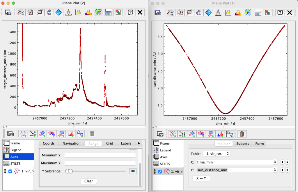
sun_distance_min/max – heliocentric distance, which controls the activity of the comet
target_distance_min / max – measured along the line of sight (= PDS’ slant distance), related to spatial resolution
solar_longitude_min / max – provides the season (= Ls), which controls the illuminated part of the nucleus
incidence, emergence, phase – illumination angles on the surface
time_min / max – time of acquisition (UTC, provided in Julian Days)
session_id and mission_phase_id — resp. provide the STP and MTP IDs (1-week and 1-month periods; the archive datasets are organized on this basis)
spectral_range_min / spectral_range_max – limits of the spectral range (given in Hz in the table)
channel_id – identifies the 3 VIRTIS channels: VIRTIS_H, VIRTIS_M_IR, and VIRTIS_M_VIS
granule_gid – a tag to distinguish calibrated data from geometry files
Additional parameters of importance include:
external_link – links to ESA’s Rosetta 3D Simulator for the current vstp (2-days period), using the reconstructed trajectory – this configuration provides the context of the observations
granule_uid and file_name – two unique identifers which include the on-board time at start of acquisition
target_name – standard name of the objet, IAU spelling (a few observations are not related to 67P)
measurement_type – measured quantity provided as a UCD (all measurements are calibrated in radiance)
Differences with the PSA / PDS archive
The current service is restored from the PI team database at LIRA/Observatory of Paris. As compared to the PSA/PDS archives:
- All data files are linked to the final calibrated version in the PSA archive. The user is referred to the PSA interface to access raw data files.
- Only basic geometry files (.GEO) are included in the PSA and PDS archives. Extended geometry files are provided here (on the LIRA website) when available, instead of the basic ones. These include Cartesian coordinates projected on shape model v7, and many additions to the standard geometry (see the geometry document). These files have extension .GE7.
- In two instances, the extended geometry file couldn’t be computed with shape7 and is provided on shape5 (both for the M channel in MTP006/STP014). The file extension is .GE5 instead of .GE7.
- Extended geometry files are however missing for H-channel files acquired in backup mode (named H1_*) and for ~500 M-channel files. In such cases, a link to the basic geometry (.GEO) is provided on the PSA.
- Geometry files are provided for all observations of the comet, not for the 60 calibration sessions on various stars.
- 25 data/geometry pairs on the comet have been recovered from the LIRA database and have an unclear status – some of these data files are not available in the PSA.
Plotting global information
Some quicklook functions are available from the VESPA portal, in particular metadata can be sent to VO tools for rapid display:
• TOPCAT will receive metadata sent as Table, to display all sort of parameters (Fig.2).

Reading spectral cubes and displaying information
Data files contain the spectral measurements of small areas on the nucleus or in the coma, calibrated in radiance; they also include the main instrumental parameters for each spectrum. Geometry files contain related information, in particular coordinates and illumination angles provided at spectrum level. Geometry was computed with the latest SPICE kernels available at the end of the mission.
Data and geometry files are stored as cubes with identical organization, so there is a one-to-one pixel correspondence between them. PDS3 spectral cubes are notoriously difficult to read, but the team software accesses such data under IDL and its open source clone GDL – this is a versatile PDS3 library with extended support for VIRTIS files, intended for detailed analysis of this dataset. Some python libraries support PDS3, beware however that the cube format is usually not entirely supported.
On-line quicklook is available via the APERICubes tool. APERICubes will receive data sent as “VIRTIS PDS cubes” from the VESPA portal menus. It will extract and plot images and spectra, and can send the results to specialized VO tools (CASSIS or SPLAT-VO for spectra, Aladin or ds9 for images; this is based on intermediate fits files with minimum headers – do not store these products).
VO tools can also plot elaborated data at spectrum level:
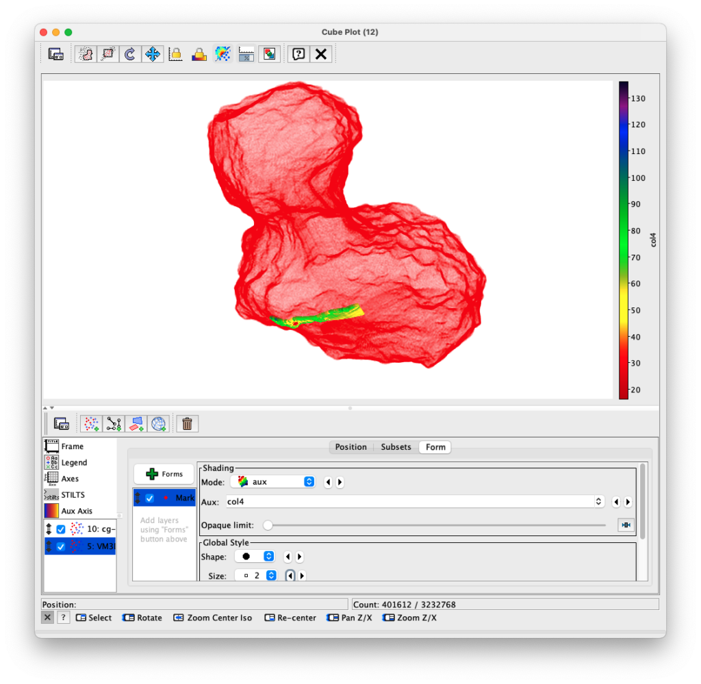
• Because of the irregular shape of 67P, few imaging tools are suitable for display at the surface, beyond simple maps using the degenerated longitude / latitude system (in which several disconnected regions overplot on the same area of the map).
• However, the extended geometry cubes also provide the 3D coordinates of each spectrum on a shape model, which is therefore embedded in the data. TOPCAT can use these coordinates to display data on the nucleus in 3D (Fig. 3). Paraview is also helpful for 3D plots but requires specifically prepared files.
A tutorial is available to illustrate data handling of VIRTIS VVEx cubes in VO tools, which is partly adapted to the Rosetta model.

Prospects
Future prospects include the addition of derived products (nucleus and coma maps, etc) from publications. Direct access to individual spectra with illumination configuration is being evaluated. The use of a more handy data format (fits with embedded geometry) is also under study.
Support services
ESA provides several services in support of the Rosetta datasets:
• A collection of the most recent shape models. VIRTIS data are projected on the Osiris shape model SPC, SHAP7 v1.8 available here. VIRTIS extended geometry files provide 2D (longitude/latitude) and 3D coordinates (Cartesian + plate ID) at each pixel corner.
Definition of geologic units on a shape model is available as supplementary material to Thomas et al 2018, 10.1016/j.pss.2018.05.019
• The Rosetta simulator provides detailed observing configurations over time (the closest configuration is provided under external_link in the EPN-TAP service).
• The comet viewer displays all NavCam images from their location on the trajectory.
• The PSA TAP server contains useful tables with extra information.
Access to VIRTIS Rosetta data and documentation
• VIRTIS Rosetta data is distributed both on ESA’s Planetary Science Archive (PSA) and NASA PDS Small Bodies Node. The PSA has both a search interface and direct access through https (called ftp access for historical reasons). It provides full access to the dataset, including raw data files, ancillary files (complete set of calibration files, instrument Spice kernels, etc) and documentation (catalogues, etc). Mission Spice kernels are available on another server as described here.
• The PSA as a whole also has an EPN-TAP interface which allows for cross-searches between datasets. Data description and search parameters are common to all files in the PSA, and are less detailed than the VIR_Ros service.
• The Rosetta mission catalog describes operations, events, and science goals during the course of the mission (this is the final version, dated Feb 2018).
• The VIRTIS archive document (EAICD) provides essential information about the instrument and dataset.
• Other documents are avalaible in their final version on the LIRA team web site (other docs included in the PSA archive may be older versions, please check version number and date).
• A hands-on manual to manipulate VIRTIS VEx data has been produced for an ESA workshop in 2014. This goes with a tutorial and solutions. This can be used to gain familiarity with Rosetta data as well.
Contact the helpdesk for comments: support.vespa@obspm.fr
_____________________
This data service is provided in the framework of the VESPA activity in Europlanet-2020 and Europlanet-2024 by Paris Astronomical Data Centre (PADC).
The Europlanet 2020 and Europlanet 2024 Research Infrastructure projects have received funding from the European Union’s Horizon 2020 research and innovation programme under grant agreements No 654208 & No 871149. Additional support was provided in France by the Action Spécifique Observatoire Virtuel and Programme National de Planétologie / INSU.


